
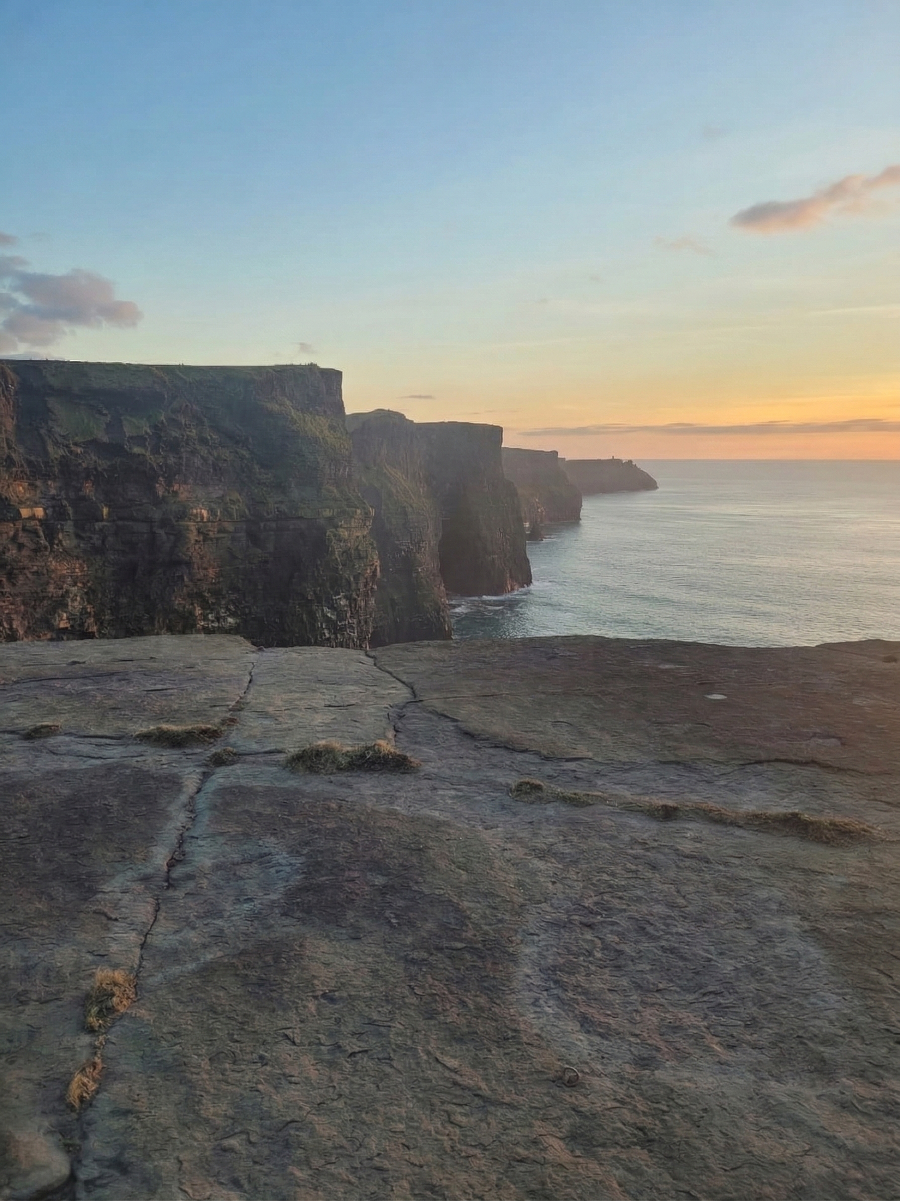

What Are the Cliffs of Moher?
The Cliffs of Moher are located on the western coast of County Clare, Ireland. They rise 214 meters (702 feet) at their highest point and stretch 14 kilometers along the Atlantic coastline. The cliffs are composed of Namurian shale and sandstone over 300 million years old. Approximately 1.5 million people visit annually, making them Ireland's most visited natural attraction.
The Cliffs of Moher are a wall of stone at the edge of Ireland. They rise vertically from the Atlantic Ocean on the western coast of County Clare, stretching 14 kilometers from Hag's Head in the south to just beyond O'Brien's Tower in the north.
At their highest point — near O'Brien's Tower — the cliffs reach 214 meters (702 feet) above sea level. That is taller than a 60-story building. Stand at the edge and look down: there is nothing between you and the Atlantic but air, wind, and the sound of waves hitting the base of rocks that are older than the dinosaurs.
On a clear day, you can see the Aran Islands in Galway Bay, the mountains of Connemara to the north, and Loop Head to the south. On the clearest days, the peaks of the Twelve Bens and the Maumturk Mountains are visible across the water.
The cliffs are not a tourist attraction that was built. They are a geological fact — 300 million years of compressed river sediment, pushed upward by tectonic forces, and carved by the Atlantic into the shape that millions of people now travel to see.
How Old Are the Cliffs of Moher?
The rock that forms the Cliffs of Moher is over 300 million years old — deposited during the Carboniferous period, long before the Atlantic Ocean as we know it existed.
The cliffs are composed of Namurian shale, siltstone, and sandstone — layers of sediment carried by ancient rivers and deposited in a shallow tropical sea that once covered what is now western Ireland. Each visible layer in the cliff face represents thousands of years of deposition. You can count them if you look closely — dark bands of shale alternating with lighter bands of sandstone, stacked like pages of a book written by geology.
The horizontal layers are what give the cliffs their distinctive stepped appearance. The rock erodes unevenly — softer shale wears faster than harder sandstone — creating the shelves, ledges, and overhangs that seabirds use as nesting sites.
The cliffs themselves are relatively young in geological terms. The current cliff face was shaped by the Atlantic over the last few thousand years, as the ocean carved into the ancient rock. The process continues — the cliffs lose material every year to erosion. The edge you stand on today was not there a thousand years ago, and the edge that exists a thousand years from now will be further inland.
Quick Geology Facts
| Fact | Detail |
|---|---|
| Age of rock | ~320 million years (Carboniferous) |
| Rock type | Namurian shale, siltstone, sandstone |
| Maximum height | 214m (702 ft) at O'Brien's Tower |
| Length | 14 km (8.7 miles) |
| UNESCO status | Part of the Burren and Cliffs of Moher UNESCO Global Geopark |
What to See at the Cliffs of Moher
O'Brien's Tower
Built in 1835 by local landlord Cornelius O'Brien as an observation point for Victorian tourists, O'Brien's Tower stands at the highest point of the cliffs. It is the landmark that appears in most photographs. The tower is open to visitors — a small fee gets you to the top for a 360-degree view of the Atlantic, the Aran Islands, and the Clare coastline.
Hag's Head
The southern end of the cliffs, named after a rock formation that resembles a woman's head looking out to sea. The walk from the visitor centre to Hag's Head is approximately 2.5 km along the cliff edge — less crowded than the main viewing areas and, many locals say, more dramatic. The ruins of Moher Tower (a Napoleonic-era signal tower from the early 1800s) sit at Hag's Head.
The Cliff Path
A walking path runs along the cliff edge — partially paved near the visitor centre, then grassy and rougher as you go further in either direction. The full walk from Hag's Head to the northern end takes approximately 3-4 hours one way. Bring layers — the wind at the cliff edge is significantly stronger than in the car park.
The Burren Connection
The Cliffs of Moher sit at the southwestern edge of The Burren — one of Europe's most extraordinary landscapes. The Burren is a karst limestone region where 70% of Ireland's wildflower species grow in the cracks of 340-million-year-old rock. Visitors to the Cliffs of Moher frequently combine the visit with a Burren drive — the two landscapes are different expressions of the same geological story.
Seabirds at the Cliffs of Moher
The cliffs are home to one of the largest seabird colonies in Ireland — over 30,000 pairs of breeding birds use the ledges, crevices, and cliff faces every year.
Species to watch for:
- Atlantic Puffins — the star attraction. Squat, colorful, and comical-looking, puffins nest in burrows on the grassy cliff tops from April to August. They are smaller than most people expect — about the size of a pigeon.
- Razorbills — black and white, standing upright on narrow ledges. They look like small penguins (they are not related).
- Guillemots — thousands of them, packed shoulder to shoulder on ledge after ledge. The noise of a guillemot colony carries for hundreds of meters.
- Kittiwakes — the cliff's own sound effect. Their "kitt-i-wake" call is identifiable from any distance.
- Fulmars — gliding effortlessly in the updrafts along the cliff face. Master flyers.
- Peregrine Falcons — the cliff's predator. Peregrines nest on the cliff face and hunt from the heights — diving at speeds over 300 km/h, the fastest animal on Earth.
The best time for seabirds is May to July, when breeding colonies are at their most active.
Visiting the Cliffs of Moher — What You Need to Know
Getting There
The Cliffs of Moher are located on the R478 road in County Clare, western Ireland.
- From Galway: ~1.5 hours drive (75 km via the coast road through the Burren)
- From Shannon Airport: ~1.5 hours (85 km)
- From Dublin: ~3.5 hours (280 km via M18 motorway)
- From Limerick: ~1.5 hours (80 km)
The Visitor Centre
The Cliffs of Moher Visitor Experience is built into the hillside — designed to be invisible from the cliffs themselves. It includes an exhibition on the geology, ecology, and history of the cliffs, a café, and a gift shop. Admission includes access to the visitor centre and cliff paths.
Practical Tips
- Wind is constant. Even on a sunny day, the wind at the cliff edge can blow with genuine force. Bring a jacket with a hood — not for rain, but for wind.
- Visibility varies dramatically. Some days you can see 100 km. Other days, fog rolls in and you cannot see the cliff edge. Check weather before you go. Clear mornings are often the best.
- Go early or late. Peak hours (11am-3pm) bring the largest crowds. Arrive before 10am or after 4pm for a dramatically quieter experience.
- Sunset visits are the most spectacular. The cliffs face west — when the sun drops toward the Atlantic, the entire cliff face turns gold and then deep orange.
- Stay on the paths. The cliff edge is unfenced in many areas. The rock at the edge is undercut and can collapse. People have died here. Respect the edge.
The Cliffs of Moher in Irish Culture
The cliffs have appeared in Irish art, poetry, and literature for centuries. They are not just scenery — they are part of Ireland's self-image. The western edge of the island, facing the Atlantic, facing America, facing the direction that millions of Irish emigrants traveled when they left.
The name "Moher" comes from Mothar, an old Irish word for a ruined fort that once stood at Hag's Head. The fort is long gone. The cliffs remain.
In modern culture, the Cliffs of Moher have appeared in:
- Harry Potter and the Half-Blood Prince (2009) — the cave scene was filmed at the base of the cliffs
- The Princess Bride (1987) — the "Cliffs of Insanity"
- Father Ted — the fictional Craggy Island is set in a landscape resembling the Clare coastline
The cliffs connect to the broader Irish heritage network. They sit in County Clare, along the Wild Atlantic Way — Ireland's 2,500 km coastal driving route. Visitors who come for the Cliffs of Moher often extend their trip north to Galway and the Aran Islands, or south to the Ring of Kerry.
Irish Heritage Jewelry Inspired by the Wild Atlantic
The Cliffs of Moher and Ireland's Atlantic coast inspire a category of men's Irish jewelry defined by raw natural power:
- Atlantic wave rings — Celtic knotwork designs inspired by the ocean patterns at the cliff base. Bold, textured, meant to look weathered.
- Celtic warrior bands — broad rings that echo the rugged Irish coastline. The cliffs themselves are a symbol of endurance — stone that has stood against the Atlantic for 300 million years.
- Connemara Marble accessories — cufflinks and tie pins made from Ireland's 900-million-year-old stone. The green marble comes from the same western coastline as the cliffs.
- Ogham name rings — Atlantic wind, cliff stone, ancient script. The Wild Atlantic Way connects the Cliffs of Moher to a heritage that stretches from Newgrange to Galway.
Wild Atlantic Jewelry for Women — Inspired by Ireland's Coast
The Atlantic coast of Ireland — from the Cliffs of Moher to Galway Bay — inspires women's jewelry that captures nature's raw beauty:
- Sea-inspired Celtic pendants — wave patterns and spiral designs drawn from the Atlantic. Sterling silver or gold, echoing the colors of sea and stone.
- Connemara Marble necklaces — green stone from western Ireland's ancient geology. Each piece carries 900 million years of the Irish landscape.
- Celtic knot earrings — the continuous line of the Celtic knot mirrors the unbroken coastline. Simple, elegant, connected to place.
- Claddagh rings from Galway — the Claddagh village sits just north of the Cliffs of Moher, at the mouth of Galway Bay. A Claddagh ring carries the same western Irish heritage.
The Wild Atlantic Way connects the Cliffs of Moher, Galway, the Aran Islands, and Connemara — a single coastline of Irish heritage.
Explore Ireland's West
- Galway — The city where the Claddagh was born
- Aran Islands — Ancient stone, ancient Irish, ancient sweaters
- Ring of Kerry — Ireland's most famous driving route
- Connemara Marble — Ireland's 900-million-year-old stone
- Irish History — 5,000 years that shaped a people
- Claddagh Ring Meaning — Born in Galway, near these cliffs
- ← Back to all guides — The complete Irish heritage hub