
What Is the Causeway Coastal Route?
The Causeway Coastal Route is a 190 km (120-mile) scenic drive from Belfast to Derry along Northern Ireland's Antrim coast. The route passes through the nine Glens of Antrim and leads to the Giant's Causeway, a UNESCO World Heritage Site consisting of approximately 40,000 interlocking basalt columns formed 50-60 million years ago. The route takes 4-5 hours to drive without stops, or 2-3 days with full exploration.
The Causeway Coastal Route runs along the coast of County Antrim from Belfast to Derry (Londonderry), a distance of 190 km. It is consistently rated as one of the most scenic coastal drives in the world.
The route follows the edge of the Antrim Plateau, where basalt cliffs drop sharply to the sea. Nine valleys, known as the Glens of Antrim, cut through these cliffs, each with its own character: glacial waterfalls, ancient woodland, and farming villages where Irish remains the daily language in some communities.
Northern Ireland's coast carries a different history from the south. This is where the Scots-Irish culture emerged, where medieval Norman castles perch on cliff edges, where the oldest licensed whiskey distillery in the world still operates, and where 40,000 hexagonal basalt columns form the geological wonder known as the Giant's Causeway.
The route can be driven in a single day (4-5 hours without stops), but spreading it over 2-3 days allows time for the cliff walks, castle ruins, and island ferries that make this coast remarkable. Most people drive from Belfast to Derry (east to west), which puts the sea on your left and the Glens of Antrim falling away below you to the right.
The Stops Along the Causeway Coastal Route
Stops are listed east to west, from Belfast toward Derry. Driving times are between consecutive stops.
H3: 1. Carrickfergus Castle, County Antrim
Built in 1177 by the Anglo-Norman knight John de Courcy, Carrickfergus is one of the best-preserved Norman castles in Ireland. It sits on a rocky promontory commanding Belfast Lough and served as the Crown's administrative center in northern Ireland for centuries. The castle was besieged by the Scots, Irish, English, and French over its 800-year military history. It remained a working garrison until 1928. King William III landed here in 1690 before the Battle of the Boyne.
Drive from Belfast: Approximately 20 minutes (17 km).
H3: 2. The Gobbins, Islandmagee
A cliff-path walk featuring tubular steel bridges bolted directly into the basalt cliff face, suspension bridges over the sea, and caves cut into the rock by Atlantic waves. The original Edwardian path was built in 1902 by the railway engineer Berkeley Deane Wise and was considered one of the most dramatic coastal walks in Europe. Reopened in 2015 after extensive restoration.
Drive from Carrickfergus: Approximately 20 minutes (18 km).
H3: 3. Glens of Antrim
Nine glaciated valleys cut through the Antrim Plateau, running from the hills to the coast. The glens, from south to north: Glenarm, Glencloy, Glenariff, Glenballyeamon, Glenaan, Glencorp, Glendun, Glenshesk, and Glentaisie. Glenariff, often called "Queen of the Glens," has a waterfall walk through old-growth forest. Cushendall and Cushendun are traditional villages in the heart of the glens. The caves at Cushendun, formed in red sandstone 400 million years ago, served as a Game of Thrones filming location.
Drive from The Gobbins: Approximately 1 hour (55 km to Cushendall).
H3: 4. Rathlin Island
A ferry from Ballycastle (25-minute crossing) reaches Rathlin, a small island with roughly 150 residents and over 250,000 seabirds. Rathlin is associated with one of the first recorded Viking raids in Ireland (795 AD, documented in the Annals of Ulster). Archaeological excavations have uncovered Viking graves and a Hiberno-Norse coin hoard from the 1040s. The RSPB seabird viewpoint at the West Light is one of the best birdwatching sites in the British Isles.
Drive from Cushendall to Ballycastle ferry: Approximately 40 minutes (35 km).
H3: 5. Carrick-a-Rede Rope Bridge
A rope bridge spanning 20 meters across a 30-meter deep chasm between the mainland and a small rocky island. Salmon fishermen originally strung the bridge to access their fishing grounds. Today it is managed by the National Trust and is one of Northern Ireland's most-visited attractions. On clear days, you can see the Mull of Kintyre in Scotland, 19 km across the water.
Drive from Ballycastle: Approximately 15 minutes (10 km).
H3: 6. The Dark Hedges
An avenue of beech trees planted by the Stuart family in the 18th century to create a dramatic approach to their estate, Gracehill House. The intertwining branches form a natural tunnel and became one of the most photographed places in Ireland after appearing as the Kingsroad in Game of Thrones. Visit early morning or late afternoon better light and fewer crowds.
Drive from Carrick-a-Rede: Approximately 15 minutes (12 km).
H3: 7. Giant's Causeway, County Antrim
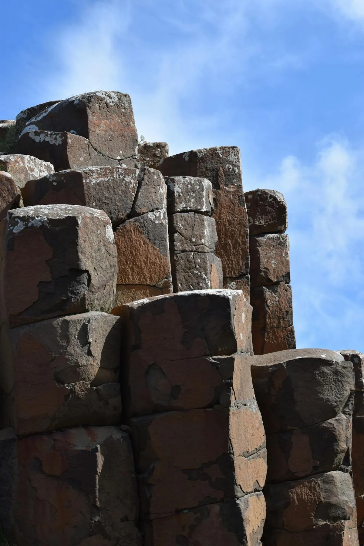
Northern Ireland's only UNESCO World Heritage Site (designated 1986). Approximately 40,000 interlocking basalt columns, mostly hexagonal, formed 50-60 million years ago when a massive lava flow cooled slowly and contracted into geometric fractures. The tallest columns reach 12 meters. Named formations include the Giant's Boot, the Organ, the Chimney Stacks, and the Wishing Chair.
Irish legend attributes the causeway to the giant Fionn mac Cumhaill (Finn McCool), who built it as a crossing to Scotland to challenge his rival Benandonner. Identical basalt columns on the Scottish island of Staffa give the legend its geographic logic.
The National Trust visitor center provides access to the causeway itself. The cliff-top path running from the Giant's Causeway to Dunseverick Castle (a 16 km walk) is one of the most scenic coastal walks in Ireland.
Drive from Dark Hedges: Approximately 20 minutes (15 km).
H3: 8. Old Bushmills Distillery
Licensed in 1608, Bushmills holds the oldest known whiskey distillation license in the world. The distillery sits on the River Bush, about 3 km from the Giant's Causeway. The connection between Irish whiskey and the landscape of the Causeway Coast runs deep. The water used in production comes from St. Columb's Rill, a tributary of the River Bush fed by the same basalt geology that created the causeway.
Drive from Giant's Causeway: Approximately 5 minutes (3 km).
H3: 9. Dunluce Castle, County Antrim
Dramatic ruins perched on a sheer basalt cliff edge overlooking the Atlantic. The castle was held by the MacDonnell clan from the 16th century, and the warrior chieftain Sorley Boy MacDonnell made it his seat of power. Archaeological excavations in 2011 uncovered a "lost town" adjacent to the castle, built around 1608, with planned streets and advanced features including indoor plumbing. According to local tradition, part of the castle kitchens collapsed into the sea during a storm in 1639.
Drive from Bushmills: Approximately 5 minutes (4 km).
H3: 10. Mussenden Temple and Downhill Demesne
An 18th-century circular temple built on the very edge of a 120-foot cliff above Downhill Strand. Modeled on the Temple of Vesta at Tivoli, it was built in 1785 by Frederick Augustus Hervey, the eccentric Earl of Bristol and Bishop of Derry. The windswept beach below stretches for kilometers and is used for sand-sailing and horse riding.
Drive from Dunluce Castle: Approximately 15 minutes (13 km).
Driving the Causeway Coastal Route: What You Need to Know
The Causeway Coastal Route runs 190 km from Belfast to Derry, taking 4-5 hours to drive without stops or 2-3 days for full exploration. Northern Ireland uses British pounds. The Giant's Causeway, Dunluce Castle, and Bushmills Distillery are all within a 5-minute drive of each other. Rathlin Island ferry operates March to November from Ballycastle.
The Causeway Coastal Route is more manageable than the Wild Atlantic Way. Here are the practical details.
| Detail | Information |
|---|---|
| Total length | 190 km (120 miles) |
| Driving time (no stops) | 4-5 hours |
| Recommended duration | 2-3 days |
| Starting point | Most people start in Belfast and drive west to Derry. |
| Best season | May to September for the longest days. Giant's Causeway and castles are open year-round. Rathlin Island ferry runs March to November. |
| Currency | Northern Ireland uses British pounds (GBP), not euros. |
| Game of Thrones | Multiple filming locations are along the route (Cushendun Caves, Dark Hedges, Ballintoy Harbor). |
| Road conditions | Mostly good A-roads. The coastal section between the Glens can be narrow and winding. |
The Causeway Coast and Irish Heritage
The Causeway Coastal Route passes through a landscape where Irish, Scots, Norse, and Norman cultures collided and merged over a thousand years.
The Norse connection runs deep. Rathlin Island was one of the first places raided by Vikings in 795 AD, and the Antrim coast became part of the Norse-Gaelic trading network that connected Dublin, Waterford, and the Scottish islands. The Hiberno-Norse art tradition that emerged from this cultural mixing is visible in the interlace patterns of Celtic jewelry (see our Celtic vs Viking guide).
The Scots-Irish heritage of the Antrim coast is the foundation of much of American Irish identity. The Ulster-Scots who emigrated to America in the 18th century carried traditions, music, and cultural identity rooted in this coastal landscape. Ten US Presidents trace their ancestry to the Ulster-Scots tradition.
The high crosses of the early Christian period are well-represented in the region, and the Celtic knotwork traditions that eventually became the basis for modern Celtic jewelry were practiced in the scriptoria and stone-carving workshops of monasteries along this coast.
Explore Celtic Heritage Jewelry →
Explore More Heritage Trails
- Wild Atlantic Way: Ireland's 2,500 km western coast, the natural counterpart to the northern route
- Ireland's Ancient East: 17 counties of eastern heritage, from Newgrange to Waterford
- Viking Trail: Follow the Norse settlements from Dublin through Waterford and Limerick
- Saint Patrick's Trail: Patrick's northern connections, including Downpatrick and Armagh